Votre e-mail a été envoyé.

Calabasas Peak Calabasas Peak Motorway Lot | Résidentiel | 11,45 ha | À vendre | 772 269 € | Calabasas, CA 91302
Certaines informations ont été traduites automatiquement.
Informations principales sur l'investissement
- Price Reduced!
- Residential Build To Suit
- 28+ Acres
- Extraordinary Views
Résumé analytique
southern California & beyond make this a strong location which will
allow unlimited creativity to a land developer. The current zoning allows
for a residential development.
Informations sur l’immeuble
| Prix | 772 269 € | Type de bien | Terrain |
| Type de vente | Investissement | Sous-type de bien | Résidentiel |
| Condition de vente | Construction sur mesure | Surface totale du lot | 11,45 ha |
| Nb de lots | 1 | ||
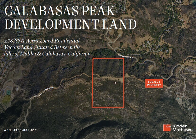
| Zonage | LCA11* - Sec/Twn/Rng/Mer: SEC 34 TWN 01N RNG 17W Brief Description: 25 MORE OR LESS ACS E 825 FT OF N 1/2 OFSE 1/4 OF SEC 34 T 1N R 17W | ||
| Prix | 772 269 € |
| Type de vente | Investissement |
| Condition de vente | Construction sur mesure |
| Nb de lots | 1 |
| Type de bien | Terrain |
| Sous-type de bien | Résidentiel |
| Surface totale du lot | 11,45 ha |
| Zonage | LCA11* - Sec/Twn/Rng/Mer: SEC 34 TWN 01N RNG 17W Brief Description: 25 MORE OR LESS ACS E 825 FT OF N 1/2 OFSE 1/4 OF SEC 34 T 1N R 17W |
1 Lot disponible
Lot
| Prix | 772 269 € | Surface du lot | 11,45 ha |
| Prix par ha | 67 455,54 € |
| Prix | 772 269 € |
| Prix par ha | 67 455,54 € |
| Surface du lot | 11,45 ha |
Parcel 4455005019 is located in the Santa Monica Mountains North Area (SMMNA). All zoning related to this parcel can be found in Title 22 of the Los Angeles Municipal Code and specifically 22.336, the Community Standards District of SMMNA.
Description
Price Reduced! Located in the Santa Monica Mountains North Area (SMMNA). All zoning related to this parcel can be found in Title 22 of the Los Angeles Municipal Code and specifically 22.336, the Community Standards District of SMMNA. The parcel is zoned for Agricultural One (A-1), which allows for residential uses. Normally the height is 35 feet but will be capped at 18 feet due to the significant ridgeline running through the middle of the parcel and close to the Calabasas Peak Motorway. In addition, you must build 50 feet vertically and horizontally away from the ridgeline. (22.336.070.R.1.b). The SMMNA has four habitat categories that are applicable community-wide: S1, S2, S3, and S4 (22.336.060.A.1), and affects development standards. Parcels is S2 and a small portion of the top of the parcel is S1. New development in S2 shall allow for a maximum building site area (BSA) of 15,0000 square feet, or 25 percent of the parcel size, whichever is less. That said, the presence of the S1 could reduce your BSA. (22.336.060.A.4.i).Other factors like the ridgeline could affect your BSA too; more on that. Regional Planning defines BSA as the approved area of a project site that is or will be developed, including building pad and all graded slopes, all structures, decks, patios, impervious surfaces, and parking areas. (22.336.020). The parcel is approximately 28 acres and could likely allow a BSA of 15K. Further, and important to note, that BSA cannot contain slopes higher than 25% or greater (22.336.070.A.4.i.) and the parcel certainly contains slopes with that range and higher, including the significant ridgeline; design accordingly with an architect. If oak trees are on the property and if development occurs within the protected zone of the oak trees (5” out from the canopy and/or 15” out from the trunk, whichever distance is greater. 22.14.150.), then an oak tree permit is needed. For further information on
Taxes foncières
| Numéro de parcelle | 4455-005-019 | Évaluation des aménagements | 0 € |
| Évaluation du terrain | 232 702 € | Évaluation totale | 232 702 € |
Taxes foncières


Présenté par
Calabasas Peak | Calabasas Peak Motorway
Hum, une erreur s’est produite lors de l’envoi de votre message. Veuillez réessayer.
Merci ! Votre message a été envoyé.