Votre e-mail a été envoyé.

Certaines informations ont été traduites automatiquement.
Disponibilité de l’espace (2)
Afficher le tarif en
- Espace
- Surface
- Durée
- Loyer
- Type de loyer
| Espace | Surface | Durée | Loyer | Type de loyer | ||
| 1er étage | 576 m² | Négociable | 226,36 € /m²/an 18,86 € /m²/mois 130 382 € /an 10 865 € /mois | Triple net (NNN) | ||
| 1er étage | 539 m² | Négociable | 188,63 € /m²/an 15,72 € /m²/mois 101 642 € /an 8 470 € /mois | Triple net (NNN) |
1er étage
- Le loyer ne comprend pas les services publics, les frais immobiliers ou les services de l’immeuble.
1er étage
LEGAL DESCRIPTION 7309, 7311 and 7317 Washington Boulevard, Elkridge, Howard County, Maryland Transcribed from Schedule A to that certain Special Warranty Deed from Southside Oil, LLC to Fuel Management Building and Land, LLC, dated September 12, 2011, effective September 13, 2011, and recorded among the Land Records of Howard County, Maryland in Liber MDR 13474, folio 0001. PARCEL NUMBER ONE 57,667 Square Foot Parcel of Land, located at 7311 and 7317 Washington Boulevard, First Election District, Howard County, Maryland BEGINNING for the same at an iron pipe heretofore set (identifying cap DAB PC) on the southeasterly right of way line of U.S. Route 1, Washington Boulevard, a right of way of varying width as shown on State Highway Administration Plats No. 52782 and 52327 as conveyed to the State Highway Administration by Deeds recorded among the Land Records of Howard County in Liber MDR 2219, at Folio 479, Liber MDR 2412, at Folio 555, and Liber MDR 3000, at Folio 283, where said right of way line is intersected by the southwesterly outline of Lot 17 as shown on the Plat of The James C. Cooney Farm as recorded among the Land Records of Howard County in Liber HBN 122, at Folio 600, and as conveyed by David Kohlhoff to John F. Baker and Catherine E. Baker by a Deed dated August 9, 1965 and recorded among the Land Records of Howard County in Liber WHH No. 439, at Folio 759. Said point of beginning also bears coordinates referenced to the Maryland Coordinate System of North 552382.6518 and East 1379065.9457. Thence from the point of beginning and binding on the southeasterly right of way line of U.S. Route 1 North 48 degrees 40 minutes 47 seconds East 200.01 feet to an iron pipe heretofore set (DAB PC). Thence leaving U.S. Route 1 and binding on a part of the second course of that tract or parcel of land conveyed by Marie S. Whitacre, Committee of Carrie M. Buffington to John F. Baker and Catherine E. Baker, by a Deed dated June 30, 1964 and recorded among the Land Records of Howard County in Liber WHH No. 420, at Folio 603 and binding reversely on a part of the first course of that tract or parcel of land conveyed by Symcha Shpak and Joan F. Shpak to Symcha Shpak and Joan F. Shpak by a Deed dated August 3, 1995 and recorded among the Land Records of Howard County in Liber MDR No. 3581, at Folio 529, South 45 degrees 04 minutes 35 seconds East 289.35 feet to an iron pipe heretofore set at the end of the second course of the second of those tracts or parcels of land conveyed by Howard Properties Holding Company to Corckran Brothers by a Deed dated June 9, 1986 and recorded among the Land Records of Howard County in Liber CMP No. 1488, at Folio 661. Thence leaving the land of Shpak and binding reversely on the said second course South 48 degrees 53 minutes 51 seconds West 200.03 feet to an iron pipe heretofore set at the beginning of said course and to intersect the aforesaid southwesterly outline of Lot 17 as shown on the aforesaid Plat of the James C. Cooney Farm. Thence leaving the second tract of the conveyance unto Corckran Brothers and binding on a part of the fourth course of the first parcel of the said conveyance unto Corckran Brothers North 45 degrees 04 minutes 52 seconds West 288.58 feet to the point of beginning hereof. CONTAINING 57,667 square feet (1.3238 Acre) of land, more or less. MORE PARTICULARLY BEING part of Parcel A as shown on the Plat entitled, "Final Subdivision Plat, Baker & Shpak Properties, Parcels A & B", which plat is recorded among the Land Records of Howard County as Plat MDR No. 12550. PARCEL NUMBER TWO 22,096 Square Foot Parcel of Land, located at 7309 Washington Boulevard, First Election District, Howard County, Maryland. BEGINNING for the same at an iron pipe heretofore set (identifying cap DAB PC) on the southeasterly right of way line of U.S. Route 1, Washington Boulevard, a right of way of varying width as shown on State Highway Administration Plat Nos. 52782 and 52327 as conveyed to the State Highway Administration by Deeds recorded among the Land Records of Howard County in Liber MDR 2219, at Folio 479, Liber MDR 2412, at Folio 555 and Liber MDR 3000, at Folio 283 where said right of way line is intersected by the first course of that tract or parcel of land conveyed by Symcha Shpak and Joan F. Shpak to Symcha Shpak and Joan F. Shpak by a Deed dated August 3, 1995 and recorded among the Land Records of Howard County in Liber MDR No. 3581, at Folio 529. Said point of beginning bears coordinates referenced to the Maryland Coordinate System NAD 83 of North 552514.7092 and East 1379216.1559. Thence from the point of beginning and binding on the second course of the conveyance unto Shpak and on the southeasterly right of way line of U.S. Route 1, as now surveyed North 48 degrees 40 minutes 47 seconds East 28.52 feet. Thence along an intersection fillet and along the third course of the conveyance unto Shpak South 86 degrees 37 minutes 31 seconds East 91.42 feet to intersect the southwesterly right of way line of Relocated Maryland Route 176, a 160' wide right of way heretofore laid out and shown on State Highway Administration Plat No. 52327 as conveyed to the State Highway Administration by Deed recorded among the aforesaid Land Records in Liber MDR No. 2219, at Folio 479. Thence binding thereon and on a part of the fourth course of the conveyance to Shpak South 41 degrees 07 minutes 19 seconds East 224.71 feet. Thence leaving the southeasterly right of way line of Relocated Maryland Route 176 and running through and across the land of Shpak for a new line of division South 48 degrees 53 minutes 51 seconds West 73.78 feet to a pipe heretofore set to intersect the first course of the conveyance unto Shpak at the end of the second course of the second of those tracts or parcels of land conveyed by Howard Properties Holding Company to Corckran Brothers by a Deed dated June 9, 1986 as recorded among the Land Records of Howard County in Liber CMP No. 1488, at Folio 661. Thence binding on a part of the first course of the conveyance unto Shpak and reversely on a part of the second course of that tract or parcel of land conveyed by Marie S. Whitacre, Committee of Carrie M. Buffington to John F. Baker by a Deed dated June 30, 1964 and recorded among the Land Records of Howard County in Liber WHH No. 420, at Folio 603 (as more particularly described in Liber HBN 123, at Folio 566) North 45 degrees 04 minutes 35 seconds West 289.35 feet to the point of beginning. CONTAINING 22,096 square feet (0.5072 Acre) of land, more or less. MORE PARTICULARY BEING Parcel B and part of Parcel A as shown on the Plat entitled, "Final Subdivision Plat, Baker & Shpak Properties, Parcels A & B", which Plat is recorded among the Land Records of Howard County as Plat MDR No. 12550. TOGETHER WITH the benefit of the restrictive covenants as set forth in Declaration of Covenants dated May 21, 1997 by Symcha Shpak and Joan F. Shpak and recorded among th
- Le loyer ne comprend pas les services publics, les frais immobiliers ou les services de l’immeuble.
Types de loyers
Le montant et le type de loyer que l’occupant (locataire) est tenu de payer au propriétaire (bailleur) sur la durée du bail sont négociés avant la signature du bail par les deux parties. Le type de loyer varie selon les services fournis. Par exemple, le prix d’un loyer triple net est habituellement inférieur à celui d’un bail à service complet puisque l’occupant est tenu d’assumer des dépenses supplémentaires par rapport au loyer de base. Contacter le broker chargé de l’annonce pour bien comprendre les coûts associés ou les dépenses supplémentaires pour chaque type de loyer.
1. Service complet: Un loyer qui comprend des services d’immeuble standards normaux fournis par le propriétaire dans le cadre d’une location annuelle de base.
2. Double net (NN): L’occupant paie seulement deux des frais de l’immeuble. Le propriétaire et l’occupant déterminent ces frais spécifiques avant la signature du bail.
3. Triple net (NNN): Un bail selon lequel l’occupant est responsable de tous les frais liés à sa part proportionnelle d’occupation de l’immeuble.
4. Brut modifié: Le brut modifié est un type général de bail dans lequel l’occupant est en général responsable de sa part proportionnelle d’une ou de plusieurs dépenses. C’est le propriétaire qui paie les frais restants. Consultez la liste ci-dessous pour connaître les structures de loyers bruts modifiés les plus courantes : 4. Plus services publics: Un type de bail brut modifié, où l’occupant est responsable à hauteur de sa part proportionnelle des services publics en plus du loyer. 4. Plus nettoyage: Un type de bail brut modifié, où l’occupant est responsable à hauteur de sa part proportionnelle du nettoyage en plus du loyer. 4. Plus électricité: Un type de bail brut modifié, où l’occupant est responsable à hauteur de sa part proportionnelle du coût de la consommation électrique en plus du loyer. 4. Plus électricité et nettoyage: Un type de bail brut modifié, où l’occupant est responsable à hauteur de sa part proportionnelle du coût de la consommation électrique et du nettoyage en plus du loyer. 4. Plus services publics et charges: Un type de bail brut modifié où l’occupant est responsable à hauteur de sa part proportionnelle des services publics et du coût de nettoyage en plus du loyer. 4. Bail industriel brut: Un type de bail brut modifié dans lequel l’occupant paie un ou plusieurs des frais en plus du loyer. Le propriétaire et l’occupant déterminent ces frais spécifiques avant la signature du bail.
5. Électricité à la charge de l’occupant: Le propriétaire paie pour tous les services et l’occupant est responsable de sa propre utilisation de l’éclairage et des prises électriques dans l’espace qu’il occupe.
6. Négociable ou sur demande: Cette option est utilisée lorsque le contact de location n’indique pas le type de loyer ou de service.
7. À déterminer: À déterminer : utilisé pour les immeubles dont le type de services ou de loyer n’est pas connu, souvent quand l’immeuble n’est pas encore construit.
Informations sur l’immeuble
| Espace total disponible | 1 115 m² | Surface commerciale utile | 1 115 m² |
| Type de bien | Local commercial | Année de construction | 1950 |
| Sous-type de bien | Immeuble de commerce |
| Espace total disponible | 1 115 m² |
| Type de bien | Local commercial |
| Sous-type de bien | Immeuble de commerce |
| Surface commerciale utile | 1 115 m² |
| Année de construction | 1950 |
À propos du bien
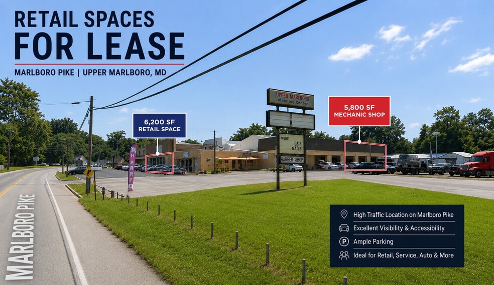
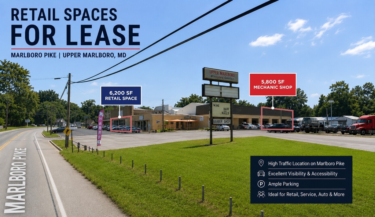
Auto Shop + Retail Space on Marlboro Pike — Upper Marlboro, MD Rare opportunity to occupy quality commercial space on high-traffic Marlboro Pike, with approximately 20,000 vehicles per day passing the site. Two distinct spaces are available — a ±5,800 SF second-generation auto shop and a ±6,200 SF retail space — offering flexibility for a single user seeking both or separate tenants for each. ±5,800 SF Auto Shop Turnkey second-generation auto shop featuring multiple service bays, existing shop infrastructure, and an efficient layout suited to general automotive repair, tire/service work, fleet maintenance, or a range of related uses. The shop includes on-site parking for customer and operational use. A large parking/storage yard is available at additional cost — offering ample room for vehicle staging, inventory, or overflow storage, a hard-to-find amenity for automotive and service operators in the market. ±6,200 SF Retail Space Prime retail space with direct frontage on Marlboro Pike, offering excellent visibility and strong signage potential. Flexible layout suitable for a range of retail, service-retail, showroom, or similar concepts. Positioned on a well-traveled commercial corridor with excellent visibility, the property provides convenient access for both retail customers and commercial fleet operations serving the greater Upper Marlboro and Prince George's County area. Highlights ±5,800 SF second-generation auto shop — turnkey ±6,200 SF retail space fronting Marlboro Pike Available together or separately On-site parking included Large parking/storage yard available at additional cost High-visibility frontage on Marlboro Pike — ±20,000 vehicles per day Established commercial corridor with convenient regional access Suitable for automotive, retail, and service users
Principaux commerces à proximité

Présenté par
15201 Marlboro Pike
Hum, une erreur s’est produite lors de l’envoi de votre message. Veuillez réessayer.
Merci ! Votre message a été envoyé.